


Location and civil engineers

A variant of the original map drawn by Dr. John Snow (1813-1858), a British physician who is one of the founders of medical epidemiology, showing cases of cholera in the London epidemics of 1854, clustered around the locations of water pumps.
Contents |
[edit] Introduction
Engineers of all disciplines need Geographic Information Systems (GIS) for the very simple reason that geospatial data makes projects faster, better, and more cost effective.
[edit] History
One of the first pieces of Geographic Information Systems (GIS) analysis was performed amidst an outbreak of cholera in London’s Soho district in 1854. The transmission mechanism for the disease was unknown at the time, so the evidence to investigate was constrained to the people who had fallen ill.
John Snow, an early epidemiologist was the first recorded person to treat this data as spatial data. He interviewed residents to understand key interactions with local environmental factors, including water pumps in the area. He put patients on a map and undertook Voronoi analysis [a spatial pattern technique] to draw a link between a single water pump and the illness, and further substantiated his findings by showing an anomaly; nearby brewery workers who should have been falling ill at the same rate were spared by their daily beer allowance, which enabled them to avoid the problem pump.
His findings are commonly cited within health geography, but rarely enter an engineering syllabus, despite his further geospatial work comparing practices of various waterwork engineering companies.
The key learning point for engineers is that if Snow had been working with merely a list of patients, he would have had no opportunity to link that list with the deadly water pump and it could have remained a medical mystery and a worsening tragedy. So where else can geospatial data uncover hidden value?
[edit] Finding a context
Whether you deal in utility networks, transportation, energy production or telecoms, your project has a location (grid coordinate, depth, height), or perhaps even a moving location, which is even more important to manage well. When an object has a location, it allows you to discover, explore, analyse and interact with its context of multiple, delicate interdependencies on built and natural environmental elements both inside and external to the project elements themselves. This might be demography, geomorphology, utility grid issues, flood forecasting, mobile phone pings of a moving population, bat records, the list goes on.
Manage these diverse elements poorly and you’ll find your project blocked at planning, poorly used once complete, inefficient to operate or perhaps just really difficult at end-of-life disposal stage. Multi-discipline project teams will come to loggerheads over mutually exclusive design decisions, construction teams will despair over how to implement environmental mitigation, and valuable information will be obfuscated at every data exchange point.
GIS (Geographic Information Systems) is of course only one tool to prevent this kind of chaos, but it’s a very important one, and one that’s frequently overlooked or seen as a competitor rather than a colleague or player within other data management systems such as BIM. Given that the big software houses on both sides are becoming increasingly intertwined, here are a few ways engineers can interact with GIS and implement it in workflows;
[edit] Layered insight
Due to the diversity of elements within the environmental context of a project, GIS is frequently the only solution which can examine them all within a single system by looking at their sole unifying factor - their location. GIS can instantly count how many trees with bat potential sit within 20km of a site or calculate the population that would suffer power outages in the event of substations flooding. It can calculate energy use baselines for a whole town on the journey to net zero, or identify every viewpoint impacted by development of a new road. Adding layers of data enables powerful analysis to be carried out.
[edit] Automating to unlock insights
GIS really lends itself to automation, via integration with sophisticated Python data libraries such as NumPy and SciPy, as well as the use of licensed tools such as FME. Using these tools allows GIS specialists to build reusable tools for iterative analysis and data processing tasks ranging from multi-sheet compulsory purchase order drawings for infrastructure development to networking tasks for water utilities.
By using multiple data sources, these insights can be updated based on changes in the surrounding area - not just changes within a project. Having an iterative source of insight into these outside changes will enable engineers to easily pinpoint and manage risk from externalities providing a more realistic view.
[edit] Crack your data management
Many of the burgeoning document management systems, such as Projectwise, don’t yet handle spatial data files well. However GIS as a sector has adapted to this technological drawback by building new links between systems to facilitate better cross-project data management.
A Spatial Common Data Environment, as we have developed at Atkins, provides a single-source-of-truth for spatial data, with visualisation tools such as 3D and 2D WebGIS already built in, to give a whole-project window for the full team. Using automated versioning, GIS can automatically allow design fixes to be shared with multi-disciplinary teams within, for example, a development consent order (DCO) process, helping to get deliverables done on time and with minimal rework.
[edit] GI-Yes for Engineers – a match made in data?
Atkins recently won accolades for their work in geospatial led design, where geospatial data on environmental constraints was considered first before a single engineer got to work. The resulting linear infrastructure centre line options handed to its civil engineers achieved the maximum avoidance of environmental, heritage and socioeconomic assets, speeding up delivery and reducing costs dramatically.
There is more data available than ever and ripe for GIS use. As our industries continue to develop digital processes, we will all need to use as much data as we can lay our hands on, and geospatial consultants alongside engineers can be the ideal partnership to ensure this happens.
This article originally appeared on the ICE Civil Engineer Blog under the title "Why it’s all about location, location, location for civil engineers". It was written by Elspeth McIntyre PIEMA, AMICE, Geospatial Consultant, Atkins and published on 1 July 2020.
--The Institution of Civil Engineers
[edit] Related articles on Designing Buildings Wiki
Featured articles and news
CLC and BSR process map for HRB approvals
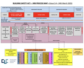
One of the initial outputs of their weekly BSR meetings.
Building Safety Levy technical consultation response

Details of the planned levy now due in 2026.
Great British Energy install solar on school and NHS sites

200 schools and 200 NHS sites to get solar systems, as first project of the newly formed government initiative.
600 million for 60,000 more skilled construction workers

Announced by Treasury ahead of the Spring Statement.

The restoration of the novelist’s birthplace in Eastwood.
Life Critical Fire Safety External Wall System LCFS EWS

Breaking down what is meant by this now often used term.
PAC report on the Remediation of Dangerous Cladding

Recommendations on workforce, transparency, support, insurance, funding, fraud and mismanagement.
New towns, expanded settlements and housing delivery
Modular inquiry asks if new towns and expanded settlements are an effective means of delivering housing.
Building Engineering Business Survey Q1 2025

Survey shows growth remains flat as skill shortages and volatile pricing persist.
Construction contract awards remain buoyant

Infrastructure up but residential struggles.
Home builders call for suspension of Building Safety Levy

HBF with over 100 home builders write to the Chancellor.
CIOB Apprentice of the Year 2024/2025

CIOB names James Monk a quantity surveyor from Cambridge as the winner.
Warm Homes Plan and existing energy bill support policies

Breaking down what existing policies are and what they do.
Treasury responds to sector submission on Warm Homes

Trade associations call on Government to make good on manifesto pledge for the upgrading of 5 million homes.

A tour through Robotic Installation Systems for Elevators, Innovation Labs, MetaCore and PORT tech.

A dynamic brand built for impact stitched into BSRIA’s building fabric.
BS 9991:2024 and the recently published CLC advisory note

Fire safety in the design, management and use of residential buildings. Code of practice.